Geomorphology of GHNP – Key Landforms and Geological Features
The Geomorphology of GHNP (Great Himalayan National Park) reveals the breathtaking and complex geological makeup of this UNESCO World Heritage Site in Himachal Pradesh. Spanning alpine regions, glacial valleys, and rugged cliffs, GHNP’s terrain showcases millions of years of tectonic shifts and glacial sculpting. Understanding the park’s geomorphology helps uncover how natural forces have shaped its present biodiversity and ecosystems.
Primary Landforms in the Geomorphology of GHNP
The geomorphology of GHNP includes a wide array of geological features that reflect both ancient and ongoing earth processes:
🔹 Alpine and Exposed Rock Areas
-
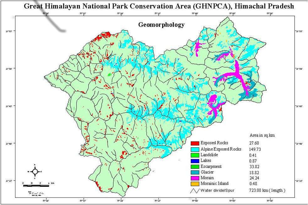
Exposed Rocks (27.60 sq. km) and Alpine Exposed Rocks (149.73 sq. km) form the skeletal structure of GHNP’s high elevations. These ancient rock outcrops are evidence of long-term weathering and tectonic uplift.
🔹 Glacial Features
-
Glaciers (83.82 sq. km) and Moraines (18.24 sq. km) dominate the upper altitudes. These features indicate past and present glacial activity, with morainic deposits showing the path of receding glaciers.
-
Morainic Islands (0.48 sq. km) within glacial lakes add to the park’s unique landforms.
🔹 Water Bodies and Slopes
-
Lakes (0.87 sq. km) formed by glacial meltwater are essential for local wildlife and biodiversity.
-
Escarpments (3.82 sq. km) and Landslide Zones (0.41 sq. km) are found along fault lines and steep river valleys, reflecting active geological change.
Why Understanding the Geomorphology of GHNP is Important
Understanding it is essential for sustainable park management, biodiversity conservation, and predicting natural hazards. It also informs trekking routes and guides ecological research. From glacial formations to exposed rocks, each feature offers insight into the natural history and ongoing geological evolution of this Himalayan wonder.